

Remote Pacific Island Challenges Qibla Direction Accuracy
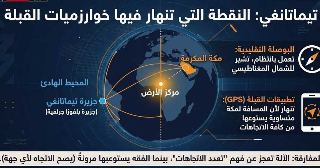
A remote island in the South Pacific, home to a small community of fewer than 60 people, has become the focal point of an unusual technological challenge involving Islamic religious practice. Residents and visitors attempting to use smartphone applications to determine the Qibla—the direction of the Kaaba in Mecca—are encountering significant technical complications due to the unique geographic positioning of their location.
For Muslims globally, the Qibla is the fundamental direction for daily prayers. While modern technology has made determining this orientation seamless for the vast majority of the world’s population, this specific island’s extreme coordinates present a complex scenario for digital compasses and global positioning systems (GPS) integrated into mobile devices. The geographic intersection at this remote site appears to create an ambiguity in the algorithms typically used by prayer-direction applications, which are often calibrated for more common latitudes and longitudes.
The difficulty arises from how software developers program these applications to calculate the shortest distance—or the ‘great circle’ path—toward Mecca. In locations where the calculated line of sight is subjected to extreme magnetic variation or software-level limitations, the accuracy of the digital compass can fluctuate significantly. For the small population on this island, this means that their smartphones, which rely on internal sensors and specific software logic, are failing to provide a consistent or reliable indicator of the direction they should face during prayer.
The situation highlights the reliance of modern religious observance on global digital infrastructure. As these applications become a standard tool for Muslims in all corners of the world, including those in geographically isolated regions, the limitations of software mapping in non-standard locations are becoming increasingly apparent.
While the issue is described as a technical anomaly rather than a spiritual barrier, it underscores the intersection of cutting-edge technology and religious tradition. For the inhabitants of this Pacific outpost, the ‘digital blindness’ of their devices regarding the path to Mecca remains a localized but noteworthy complication. Local users are currently seeking alternative, traditional methods to calculate their alignment with the holy city, demonstrating that even in an era defined by constant connectivity, geographic and technical constraints can still require manual intervention to ensure the precision required for daily worship. The case serves as a rare example of how specific, extreme global positioning challenges can impact the digital tools used by the MENA region’s wider diaspora and the global Muslim community at large.